Pico Rivera
Community History
Pico Rivera is a fast-growing city of about 65,200 people in a more than eight-square-mile area located on the eastern border of the Los Angeles basin and southern border of the San Gabriel valley. Called Sejat by Native Americans who believed that the world began in the area where the city is now, Pico Rivera today has changed from its original forested and bucolic state into an urban region easily accessible by car (via the Pomona, Santa Ana, and San Gabriel freeways), plane (via Los Angeles International Airport), and train (via the Union Pacific Railroad, Southern Pacific Line, and the Atchison, Topeka and Santa Fe Railway Company).
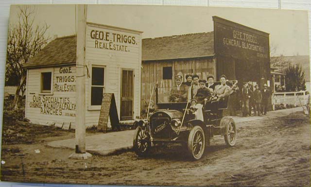
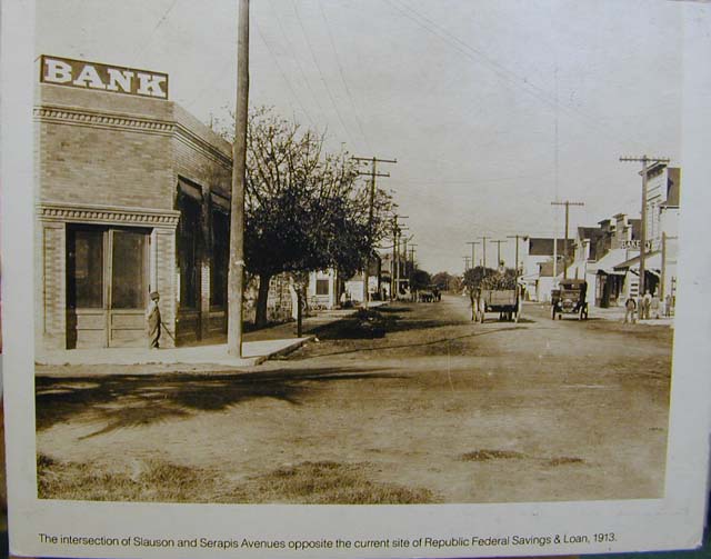
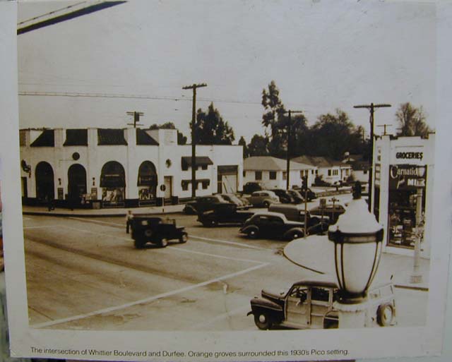
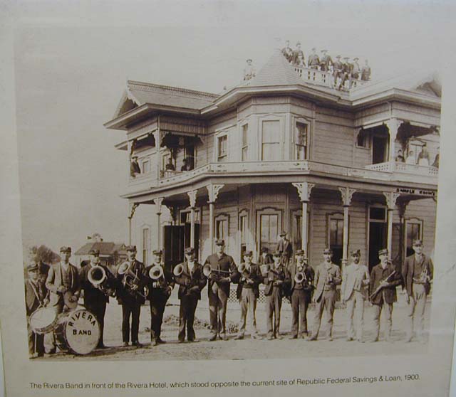
The towns of Pico and Rivera, from which the city originated, officially began in the 1880s when the Union Pacific and Atchison, Topeka and Santa Fe railroads built rail lines through the region. Blessed with fertile soil, both communities became known for their walnuts, avocados, and other crops, and retained their agricultural character through the mid-1940s. When a growing influx of new residents came to Pico Rivera after the end of World War II, development began supplanting farming as the landscape became dotted with housing subdivisions, schools, stores, and churches.
As the population grew, so did residents’ collective sense of civic duty and desire to blend the two separate towns. On January 7, 1958, the majority of voters in Pico and Rivera voted to incorporate as one municipality and with the decision becoming official that January 29, Pico Rivera became Los Angeles County’s 61st city.
Image Gallery


Frequently Asked Questions
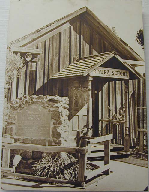
The origins of what is now Pico Rivera date back prior to California’s joining the Union in 1850, when the state’s territory was still under Mexican rule. Today’s property ownership has evolved from purchases made then of Rancho Paso de Bartolo by Pio Pico, a political rebel who became California’s last governor under Mexico, and Rancho Santa Gertrudes by Doña Josefa Cota, widow of Don Antonio Maria Nieto. In 1855, Oliver Perry Passons became the first American to own property in the area when he bought 100 acres. Among the earliest settlements in the area were Gallatin (now part of Downey), an area known as Ranchito, the so-called Barton ranch, and a farming community known as Maiseland for its corn crop. The building of railroad lines in the 1880s prompted the official start of the communities of Pico and Rivera.
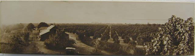
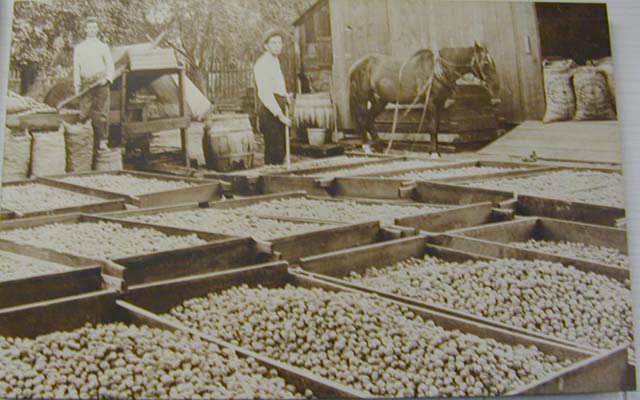
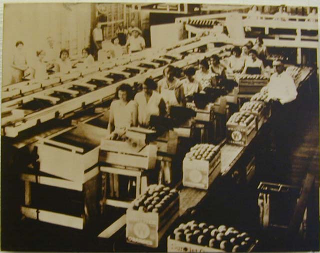
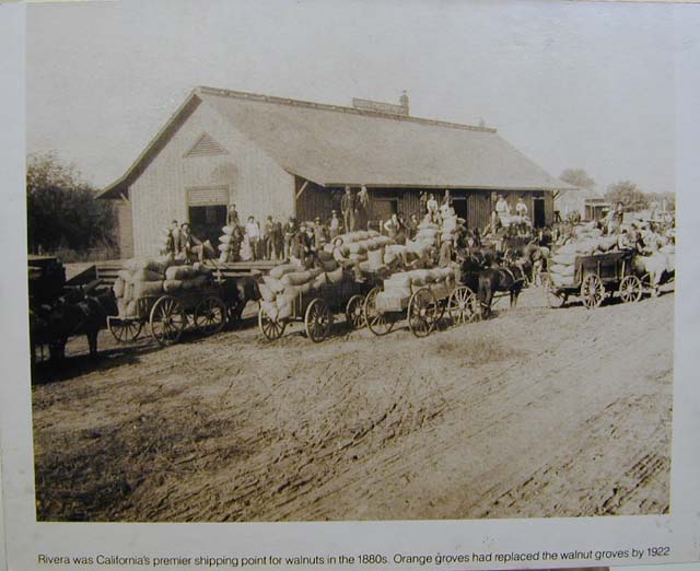
From their origins in the mid-1800s through the mid-1940s, Pico and Rivera-the towns that later became the city of Pico Rivera-flourished as agricultural communities with the help of fertile soil between the Rio Hondo and San Gabriel rivers and a water table near the surface of the land. In fact, the earth was so rich that fence posts cut from willow trees were reported to have sprouted and grown into trees themselves! Cattle ranching had been the dominant agricultural undertaking prior to the Civil War, but that ended with a severe drought from 1862 to 1865 which forced the breakup of large farms into smaller parcels. Farmers then grew corn and grapes for wine-making, and starting in 1875 added walnuts, which soon overshadowed other crops as the dominant agricultural product-to the point where the first walnut shipment out of California took place in Rivera. Their growth and export dropped off after the start of the twentieth century due to disease, insects, and a dropping water table. Around that time orange groves stated to supplant walnut trees, and avocados also started being cultivated in the region. The prime farmland that characterized the Pico Rivera area started to be usurped by housing developments after World War II as the state’s population grew, and barns and silos were replaced by homes, schools, and churches.
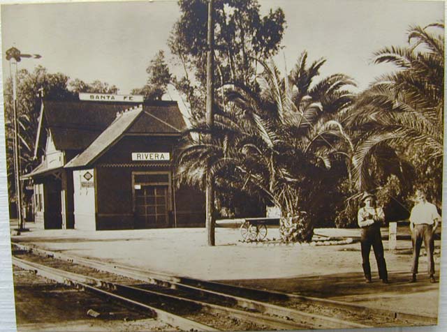
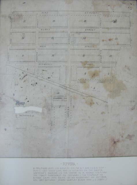
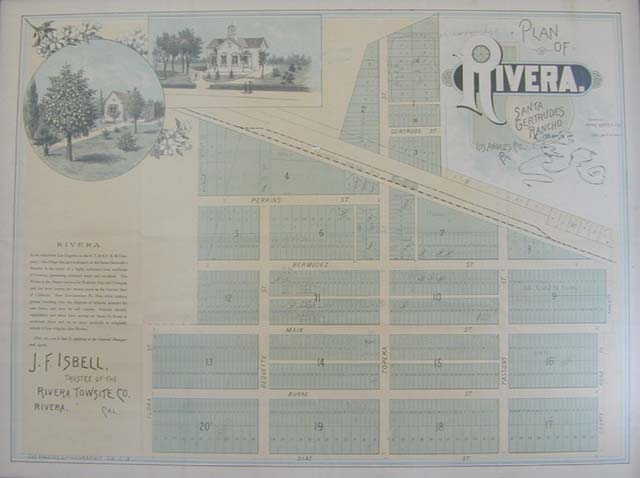
Pico Rivera owes its existence to the extension of railroad lines in California in the late nineteenth century. The two communities of Pico and Rivera-which made up what is today’s city – came into being in the 1880s with completion of rail lines for the Union Pacific and Atchison, Topeka, and Santa Fe railroads. The first passenger train reportedly arrived in the area in 1887, with residents traveling by buggy and wagon to meet it.
The names for the original communities of Pico and Rivera were inspired, respectively, by a prominent early settler in one and the geographical qualities of the other. Pio Pico in 1845 became governor of California, the last Mexican governor before the state entered the Union in 1850, and he was the original landowner of the town of Pico. Rivera, the northernmost of the two communities, was so-named for its location between the Rio Hondo and San Gabriel rivers.
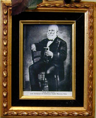
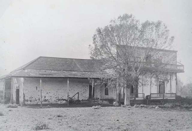
Pio de Jesus Pico, later known as “Don Pio Pico,” was California’s last governor under Mexican rule before the state joined the Union in 1850. He was born to parents who traveled from Mexico to California with Captain Gaspar de Portola’s party of several hundred people, which arrived at the San Gabriel Mission in the mid-1770s. While still a boy supporting his family after his father’s death, Pico became interested in politics after observing citizens standing up to military officials on the grounds that they were entitled to citizens’ rights. He became a member of a representative citizens’ group called the disputacion, and in 1831 led a revolt against Governor Victoria, emerging victorious enough to be made temporary governor. From then on his power, influence, and monetary worth grew in southern California, and following a series of battles between his rebels and the armies of Monterey governors he was again made governor of California. Following unsuccessful efforts to thwart the United States invasion and conquest of California, Pico channeled his energy into starting banking, education, and municipal organizations and institutions.
He was instrumental in the startup of what became the Standard Oil Company of California, served on the Los Angeles City Council, and built the Pio Pico mansion. Fate struck him a cruel blow in 1883, when he signed what he thought was a property loan that instead defrauded him of all his property, which at the time was valued at about $200,000. Though he sued for damages and won at the State Supreme Court level after seven years of court battles, he received no financial compensation and became destitute at age 91. He died at his daughter’s home in Los Angeles on September 11, 1894. Today his name lives on in state parks, schools, roads, and other entities named after him, and his mansion-deeded in 1914 to the state of California-has since been restored.
Rapid and sweeping post-war development in the rural towns of Pico and Rivera laid the groundwork for their merging into one city that combined both names. Pico and Rivera began separately in the 1880s with the construction of rail lines through the region, and then grew slowly through the mid-1940s. With a population surge after World War II, developers bought out farmland and subdivided it for houses and other building. As the population grew and local landmarks and farmland gave way to new construction, families from both communities grew closer and their civic duty strengthened, and by the mid-1950s many residents of Pico and Rivera decided they wanted to incorporate as one municipal entity.
In the spring of 1957 residents circulated a petition to incorporate, and on January 7, 1958 – despite fierce opposition to the idea from some people – 56 percent of the voters of Pico and Rivera voted to incorporate as one community. A similar battle ensued over the name of the new municipality, with some favoring the name “Serra City,” but following a public ballot to resolve the issue the name Pico Rivera was chosen. A Council-Manager form of city government was approved, five people were chosen to serve as the first City Council members, and on January 29, 1958, Pico Rivera was incorporated as Los Angeles County’s 61st city.
Today, the population of fast-growing Pico Rivera exceeds 65,200 people over more than eight square miles, and by 2002 the population base is expected to increase by 21 percent from its 1980 level.
The first Native Americans to live in the region were the Awignas, later called Gabrielinos by Spanish settlers who first arrived around 1770 and named them after the San Gabriel Mission. Prior to the arrival of Anglos, the Gabrielinos were one of the wealthiest, most powerful, and most influential group of Native Americans in southern California. They lived in the general watershed areas of the Los Angeles basin; the Los Angeles, San Gabriel, and Santa Ana rivers; streams in the Santa Ana and Santa Monica mountains; coastal land between Aliso and Topango creeks; and San Clemente, San Nicolas, and Santa Catalina islands.
The Awignas who inhabited the area near what is now Pico Rivera lived in villages dotting the banks of San Jose Creek and stretching south from what is now the Pio Pico Mansion, inhabiting conical dwellings made of reeds, tule, and willows. Though the Native Americans did not live in the often-flooded lowlands of the San Gabriel Valley, they lived off the plentiful ducks, geese, rabbits, berries, and black honey made by bees that burrowed into the ground there, as well as seeds and nuts they found in nearby hills. The Awignas bestowed upon Pico Rivera the greatest honor of all by claiming that this was where the world began, calling it Sejat for “the place where the bees burrowed in the ground.” These legends were recorded in 1841 by Father Geronimo Boscano as part of a sweeping oral history project with native Americans. During the twentieth century, Smithsonian Institution researcher John P. Harrington found a possible riverbank site – in what is now Pico Rivera – that is the alleged location of Sejat.
The first white men to arrive in the region came through on January 18, 1770, in an expedition looking for Monterey Bay. Less than two years later, the Awigna’s bucolic life ended for good on September 8, 1771, when European priests and soldiers arrived to spread Christianity, established the San Gabriel Mission, and renamed the Native Americans the Gabrielinos. The Anglo newcomers abused the Native American population which led to fatal confrontations and, especially, the violent death of the local Indian chief.
Several years later, in the mid 1770s, Spanish soldier Juan Bautista de Anza was hired by the Spanish government to find a route across the desert from Mexico to California. Anza’s party reached a Yuma Indian village, where he encountered a Native American named Sebastian Tarabal who had run away from the San Gabriel Mission and was on the verge of dying in the desert when the Yumas found him. In a bitter twist of fate for Tarabal, he ended up guiding the Anza party back to the very mission from which he had fled, and in the process helped Anza open up a trade route that immediate drew settlers to California.
In 1784, Jose Manuel Nieto – a soldier in Captain Gaspar de Portola’s reconnaissance expedition – received from the Spanish crown a reward of 300,000 acres for cattle grazing between the Santa Ana and San Gabriel rivers. About 20 years later, Juan Crispin Perez started grazing cattle on the property, and following Nieto’s death successfully petitioned in 1833 for the property. Following Perez’ death in 1846, Pio Pico bought the property – greatly reduced in size from Nieto’s vast acreage – for $4,642. In 1852 Pico built an adobe house that he named El Ranchito, much of which remains part of today’s Pio Pico Mansion. Pico later sold some parcels to new settlers and lost the rest in a court battle in the 1890s.